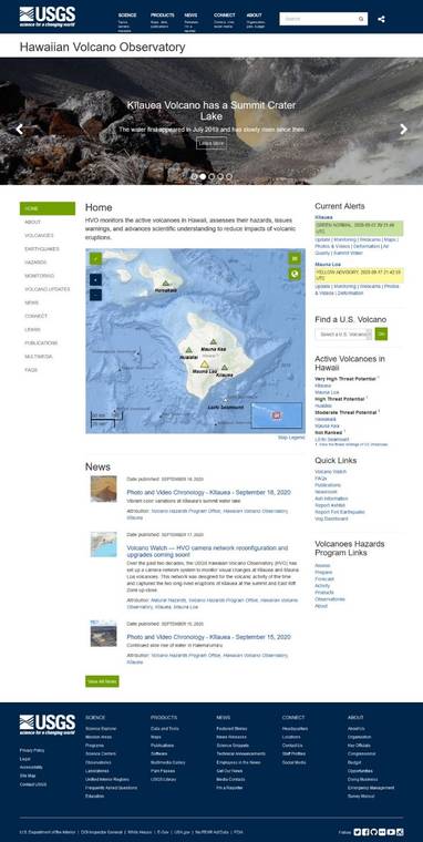
You may have seen the Yellowstone Volcano Observatory’s “Caldera Chronicles” article about their new-and-improved website, in which they hint at a change coming to the Hawaiian Volcano Observatory’s (HVO) website, too. It’s true!
This week, HVO is the latest of several USGS volcano observatories (Yellowstone Volcano Observatory, Cascades Volcano Observatory, and California Volcano Observatory) to reveal a new website. This continues our effort to more efficiently provide the public with up-to-date information on Hawaiian volcanoes.
The original HVO website premiered in 1998 and its appearance remained essentially unchanged until 2017. That year, HVO revamped its original website (see our May 18, 2017, “Volcano Watch” for details ).
HVO’s 2017 website revision was just one piece of a larger effort that included most other volcano observatories within the USGS Volcano Hazards Program (VHP). At the time, informational content and volcano monitoring data for HVO and most other USGS volcano observatories were gathered into a database.
This database then fed the content and data to similarly formatted USGS volcano observatory websites, which offered consistent experiences to visitors. The availability of dynamic data, such as real-time seismic maps and ground deformation plots, was a major improvement.
Like the 2017 website transition, the HVO website launched this week is just one small piece of a much larger effort that includes not only the volcano observatories, but the entire USGS! This year, the VHP’s “webolution” joined other programs within the USGS, many with websites that have already migrated to this new system.
This new system, essentially a larger database, will house the content and data to drive websites for all USGS programs, including the Coastal and Marine Hazards and Resources Program and the Earthquake Hazards Program, as well as the VHP. Each USGS program is part of a larger Mission Area, with the VHP and other hazards-related programs included in the USGS Natural Hazards Mission Area.
Unlike the past website transition, which looked different from its predecessor and unveiled new content, today’s HVO website doesn’t look dramatically different than the 2017–2020 website. The content on the new website is essentially the same — it’s just formatted slightly differently.
On the full-sized version (using a tablet or computer), users can still access Hawaiian volcanoes information and data via a menu of options viewed on the left-hand side of the screen, with a list of shortcuts to our most popular pages available on the right-hand side. News items are listed at the bottom of the homepage. The new website maintains the dynamic data streams — seismic maps, deformation plots, and webcam imagery of Hawaiian volcanoes — of the old website.
But an exciting and major improvement on the new HVO website is that it’s more mobile-friendly. With almost half of our website visitors doing so via mobile devices, it’s now easier to check the status of Hawaiian volcanoes at any time and from any device. Our new website will automatically re-size a page when viewed on smaller screens, which meets the federal mandate to make our data and volcano information more accessible.
One of the biggest changes to the new HVO website is its dynamic connection to USGS-wide pages. By integrating HVO’s website with the rest of USGS, we can easily share information on Hawaiian volcanoes. For example, when posting new content, we can choose to share it only on the HVO website, or we can choose to simultaneously share it to the VHP, the Natural Hazards Mission area, and other relevant USGS websites to reach a wider audience.
This capability ensures that HVO, with its mission to monitor active volcanoes and their hazards, can share vital information more broadly when necessary. It also helps you — the user — more easily find information, data, and content related to the subject that interests you. You can search for anything across all USGS pages in the box at the top of the website.
We hope that learning to navigate HVO’s new-and-improved website will be fun — explore it at www.usgs.gov/hvo. As always, feedback is welcome at askHVO@usgs.gov.
Visit www.usgs.gov/observatories/hawaiian-volcano-observatory for past Volcano Watch articles, Kilauea and Mauna Loa updates, volcano photos, maps, recent earthquake info, and more. Email questions to askHVO@usgs.gov.
Volcano Watch is a weekly article and activity update written by U.S. Geological Survey Hawaiian Volcano Observatory scientists and affiliates.
Volcano Activity Updates
Kilauea Volcano is not erupting. Its USGS Volcano Alert level remains at NORMAL (https://www.usgs.gov/natural-hazards/volcano-hazards/about-alert-levels). Kilauea updates are issued monthly.
Kilauea monitoring data for the past month show variable but typical rates of seismicity and ground deformation, low rates of sulfur dioxide emissions, and only minor geologic changes since the end of eruptive activity in September 2018. The water lake at the bottom of Halemaumau continues to slowly expand and deepen. For the most current information on the lake, see https://www.usgs.gov/volcanoes/Kilauea/k-lauea-summit-water-resources.
Mauna Loa is not erupting and remains at Volcano Alert Level ADVISORY. This alert level does not mean that an eruption is imminent or that progression to eruption from current level of unrest is certain. Mauna Loa updates are issued weekly.
This past week, about 103 small-magnitude earthquakes were recorded beneath the upper-elevations of Mauna Loa; most of these occurred at shallow depths of less than about 5 miles. GPS measurements show long-term slowly increasing summit inflation, consistent with magma supply to the volcano’s shallow storage system. Gas concentrations and fumarole temperatures as measured at both Sulphur Cone and the summit remain stable. Webcams show no changes to the landscape. For more information on current monitoring of Mauna Loa Volcano, see: https://www.usgs.gov/volcanoes/mauna-loa/monitoring.
There was one event with three or more felt reports in the Hawaiian Islands during the past week: a magnitude-2.8 earthquake struck about 4 miles east-northeast of Pahala on Sept. 17 at 8:54 p.m.
Visit www.usgs.gov/observatories/hawaiian-volcano-observatory for past Volcano Watch articles, Kilauea and Mauna Loa updates, volcano photos, maps, recent earthquake info, and more. Email questions to askHVO@usgs.gov.
Volcano Watch is a weekly article and activity update written by U.S. Geological Survey Hawaiian Volcano Observatory scientists and affiliates.

